|
A joint domain is a joint system in an area that has a particular well-defined pattern comprising one or more joint sets. Variations in joint pattern across an area or a broader region may define different joint domains. One of the well-known examples of this is the variation of cross-joint pattern along the northern Appalachians Mountain belt (Figure 1). This variation has been attributed to the Alleghanian stress field rotation or what is known as oroclinal bending (Engelder and Geiser, 1980; Zhao and Jacobi, 1997).
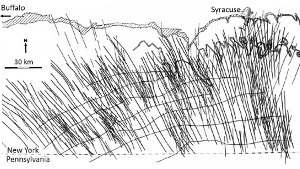 | | Figure 1. Pervasive cross-joints at large scale along the northern Appalachians Mountain belt (the inferred stress trajectories are also shown). Scale bar is 30 km. These regional joint sets are usually referred to as fold axis–perpendicular sets or cross-joint sets, the orientation of which varies along the orogenic belt. From Engelder and Geiser (1980). |
Another intriguing pattern of joints and slightly sheared joints can be found on the flanks of the Salt Valley Anticline at Arches National Park (Utah) studied in detail by several geologists (Dyer, 1983; Zhao and Johnson, 1992; Cruikshank and Aydin, 1994; 1995). The regional structure is a broad salt cored anticline with shaley rocks and occasional salt intrusions at the core and shallowly dipping well-bedded sandstone at the flanks (Figure 2). The salt belongs to the Paradox Formation of Pennsylvanian age and the limbs of the anticline are made up of primarily Jurassic Entrada Sandstone with spectacular joint networks.
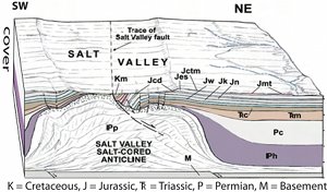 | | Figure 2. Block diagram showing a salt-cored anticline known as the Salt Valley Anticline at Arches National Park, Utah. Many of the joint systems used in this Knowledgebase are from the Jurassic Entrada Sandstone (Jes) outcropping on both the NE and SW flanks of the anticline. The core of the anticline has been breached resulting in salt dissolution and collapse such as the tilted and faulted Mesozoic formations depicted above the salt on the NE side. Cropped from a larger section by Doelling (2000). |
The map in Figure 3 shows the Moab Member and the stratigraphically lower darker colored Slick Rock Member (actually reddish in the following color photographs in Figure 4) of the Entrada with the traces of joints or joint zones highlighted by yellow lines in selected areas. The NE limb contains remarkably consistent strike-parallel curvilinear systematic joints or joint zones extending many kilometers and circling the core of the anticline made up of older fine-grained shaley rocks and occasional salt intrusions. It is well-known that this system was sheared following its formation as an opening mode fracture system as evidenced by occasional measurable offsets and the splay fracture set confined between the neighboring sheared systematic joints and joint zones (Figure 4). What appear to be continuous lineaments are actually segmented and the segment tips play an important role in the initiation and propagation of the next generation joints. The regional joint network map shows that there is departure from the systematic orientation in the lower NE corner of the map due to the approaching intersection with the Cache Valley salt structure in the southeast.
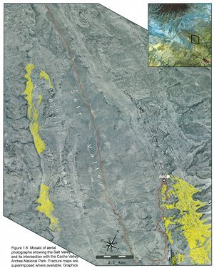 | | Figure 3. Mosaic of aerial photographs showing the Salt Valley and its intersection with the Cache Valley, Arches National Park, Utah with the fracture traces marked in the Jurassic Entrada Sandstone cropping out at the flanks of the Salt Valley Anticline. Fracture maps are superimposed where available. Graphic by Xavier DeBernard Roche. |
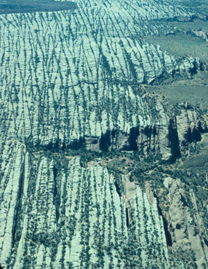 | | Figure 4. Aerial view of non-orthogonal joint sets with low intersection angle in the Jurassic Entrada Sandstone cropping out on the NE flank of the Salt Valley Anticline at Arches National Park, Utah. View due down and northwest and the width of the photograph at the bottom is about one kilometer. The white colored rocks belong to the Moab Member of the Entrada Sandstone and the red rocks below are the Slick Rock Member. The systematic set swings gradually from the view direction at the bottom of the photograph to more NW-SE orientation at the top locally tracing the bedding strike. Please see Dyer (1983) and Cruikshank and Aydin (1995) for additional photographs, maps, and diagrams of the joint patterns in Arches National Park. |
A series of maps in Figure 5 and Figure 6 and one detailed photograph taken from a small airplane show various joint domains and the transition from one domain to another primarily in the Entrada Sandstone in the southwestern limb of the Salt Valley Anticline. Figure 7 is an aerial photograph showing the transition from one domain to another. Using the abutting relationships and confinement of members of one set by the members of another set, it is possible to determine that the approximately NS-trending set is older than the NW-trending set. Furthermore, since many of the NW-trending set members initiated as splay fractures from the tips of the NS trending set, the older set is inferred to be subject to left-lateral shearing at the time of the formation of the younger set. Generally, this sequence of joint sets is consistent in the southwestern flank of the anticline and their sharp changes of orientation are in contrast to generally curvilinear traces of the morphological traces of joint zones on the northeastern limb of the anticline.
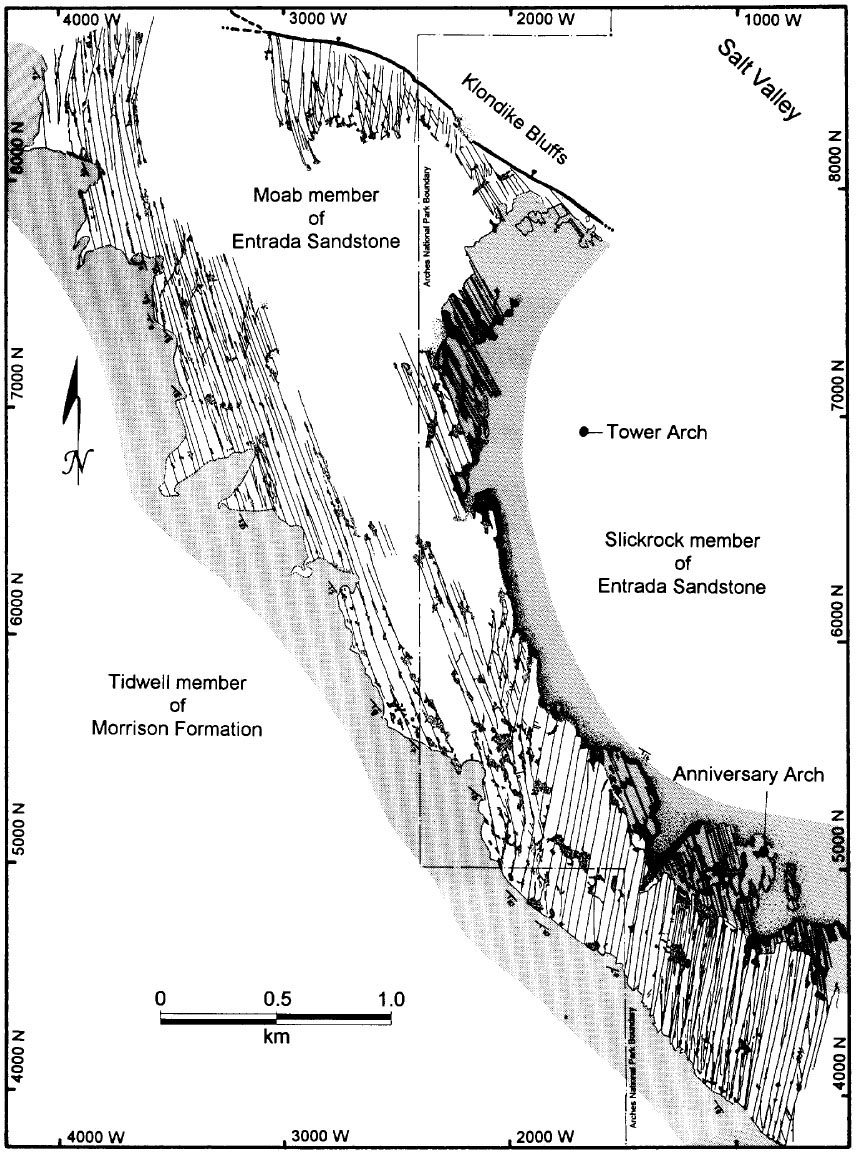 | | Figure 5. Structure map showing joint domains in the Moab Member of the Entrada Sandstone exposed on the SW flank of the Salt Valley Anticline, Arches National Park, Utah. All fractures in the map originally formed as joints but the older sets were subjected to minor amounts of shear when the younger sets formed based on the geometric relationships between the parent fractures and their splays. From Cruikshank and Aydin (1995). |
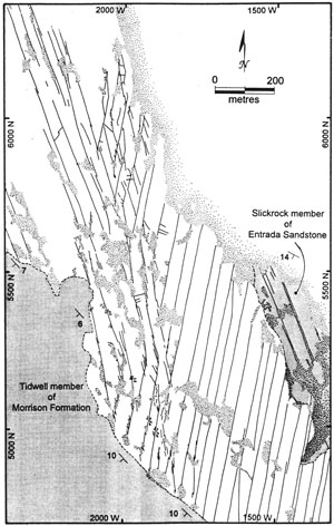 | | Figure 6. Details of the transition from one set to another forming various joint domains (see dashed lines in Figure 1 for location). The abutting relationship and the confinement of one set by the other reveal the relative ages and formation mechanism of the fracture pattern. Even though each set originally formed as joints, the NE-trending fractures have been subjected to a left-lateral shearing on the order of a few centimeters and the spatial distribution of the tips of their segments dictated the initiation of the splay joints in NW orientation and their subsequent distribution. From Cruikshank and Aydin (1995). |
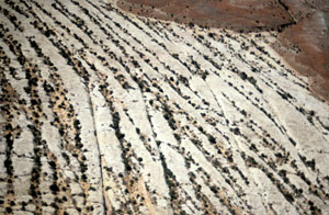 | | Figure 7. Aerial photograph showing the interrelationships between two sets of joints in a joint domain in the lower part of the map in Figures 2 and 3 above. The through-going set at the bottom half of the photo is the earlier set (N-S with respect to the photo) and the NW-trending set formed later. Note that members of the younger set are confined between members of the older set at the bottom half of the photo. |
Although the development of jointing in 3D cannot be readily seen in these maps and photographs, a portion of the older Slick Rock Member of the Entrada Sandstone outcropping underneath the Moab Member along scarps immediately to the east of the mapped area displays a NW-trending joint set indicating that, at least, the NW-trending sets occur in both of these units. However, the occurrence of the different joint domains in a vertical sequence of lithological formations or members cannot be ruled out.
Figure 8 is a map of an aerial photograph showing traces of joints and joint zones in various domains in Aztec Sandstone in Valley of Fire State Park, southeastern Nevada (Deng et al., 2015). The joint zones (blue lines) follow roughly a straight trace. Cross-bed confined joints occur perpendicular to, and terminate at, cross-beds (Figure 9), indicating cross-bed geometry controls the geometry and distribution of the joint domains. It is an interesting mechanism of the formation of joint domains, which will be discussed in 'Mechanisms and Mechanics of Joint Domains.'
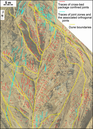 | | Figure 8. Map showing cross-bed confined joint system and joint zones with associated orthogonal joint systems in a series of dunes with variable cross-bedding orientation in Aztec Sandstone exposed at Valley of Fire State Park. Revised from Deng et al. (2015). |
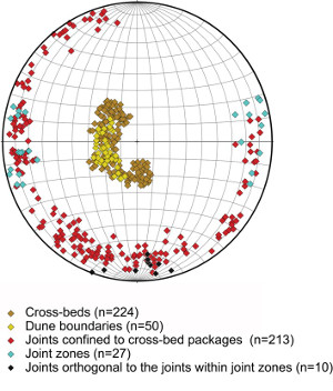 | | Figure 9. Stereo-net plot showing the orientation of the cross-beds and joints in Figure 8. The orientation of joint zones (blue color code) is quite consistent while those confined to cross-bed packages (red color code) show a wide variation. Modified slightly from Deng et al. (2015). |
| |
Cruikshank, K.M., Aydin, A., 1994. Role of fracture localization in arch formation, Arches National Park, Utah. Geological society of America Bulletin 106: 879-891.
Cruikshank, K.M., Aydin, A., 1995. Unweaving the joints in Entrada Sandstone, Arches National Park, Utah, U.S.A.. Journal of Structural Geology 17: 409-421.
Deng, S., Cilona, A., Morrow, C., Mapeli, C., Liu, C., Lockner, D., Prasad, M., Aydin, A., 2015. Cross-bedding related anisotropy and its interplay with various boundary conditions in the formation and orientation of joints in an Aeolian sandstone. Journal of Structural Geology 77: 175-190.
Doelling, H.H., 2000. Geology of Arches National Park, Grand County, Utah. In: Sprinkel, D.A., Chidsey, Jr., T.C., Anderson, B.P., Geology of Utah’s Parks and Monuments. Utah Geological Association Publication 28: 11-36.
Dyer, J.R., 1983. Jointing in sandstones, Arches National Park, Utah. Ph. D. Dissertation, Stanford University, 202 p.
Engelder, T., Geiser, P.A., 1980. On the use of regional joint sets as trajectories of Paleostress fields during the development of Appalachian Plateau, New York. Journal of Geophysical Research 85 (B11): 6319-6341.
Zhao, G., Johnson, A.M., 1992. Sequential of deformation recorded in joints and faults, Arches National Park, Utah. Journal of Structural Geology 14 (2), 225-236.
|


