|
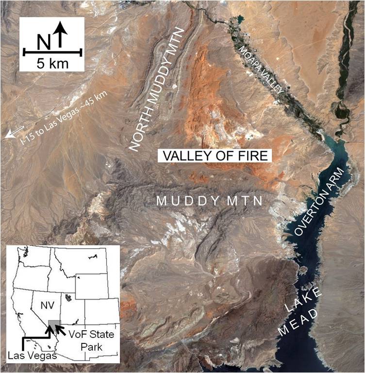
The Valley of Fire State Park and its immediate vicinity, about 60 km northeast of the city of Las Vegas in southeastern Nevada (Figure 1), is a natural field laboratory for structural geology in general, and for fractures and faults, particularly deformation bands. The park proper is located between the Overton Arm of Lake Mead and its extension to the north, the Moapa Valley. The broader park area is bounded by the Muddy Mountain in the south and the North Muddy Mountain in the west. Here we will provide a short overview of the structures and tectonics of the whole park, although particular structure types and their attributes were presented in great detail in various other sections of this Knowledgebase.
 | | Figure 1. Satellite image showing geographic and physiographic features of Valley of Fire and its surroundings. Inset map shows the location within the western United States of America. |
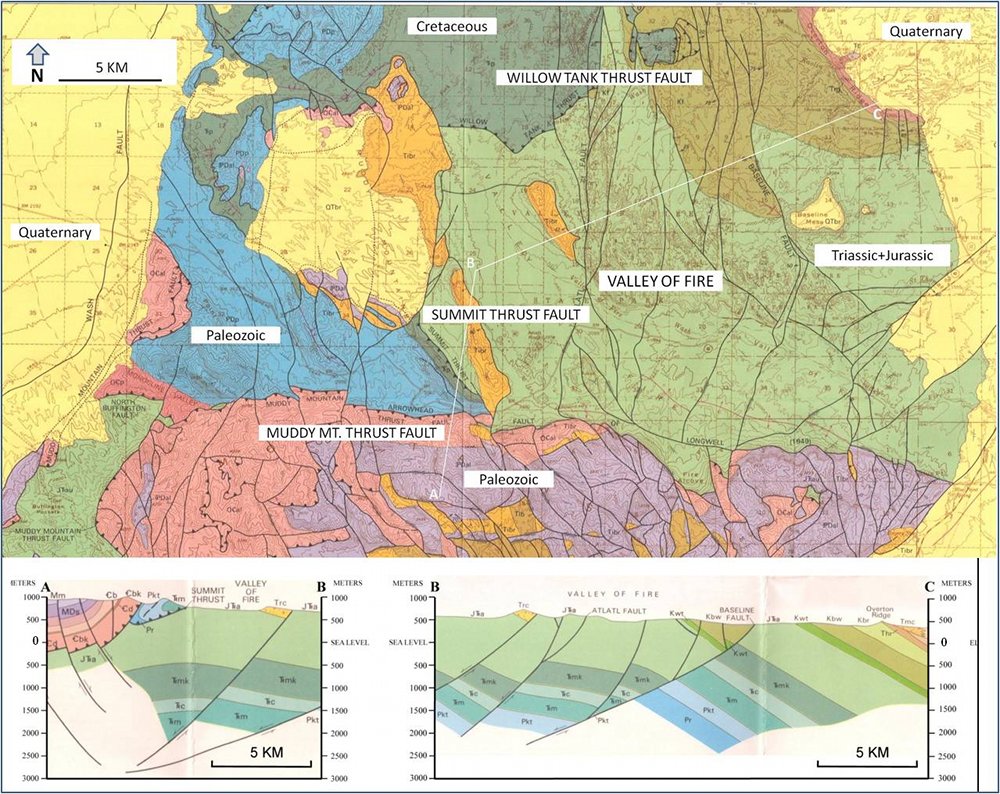
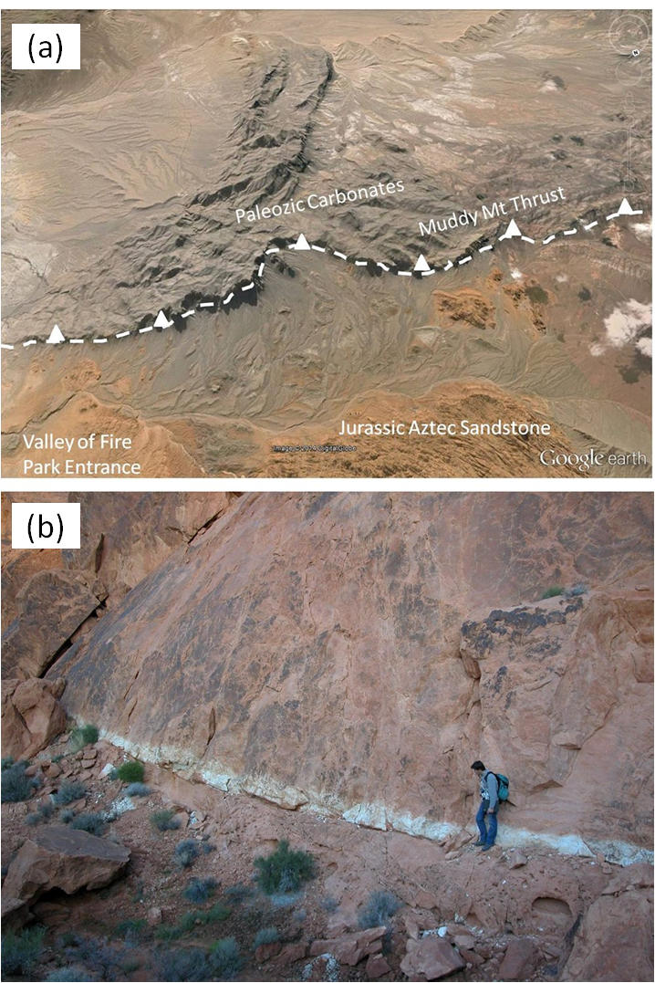
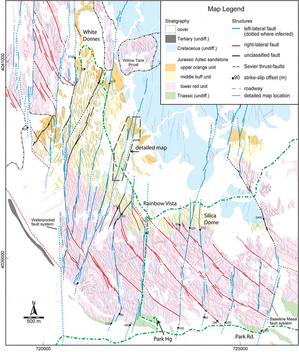
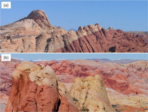
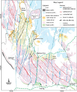
The Muddy Mountain and the North Muddy Mountain are the type localities for the Late Cretaceous Sevier fold and thrust belt in southeastern Nevada (Bohannon, 1983a; Carpenter and Carpenter, 1994). There are at least three major thrust faults of this belt exposed in the park: The Muddy Mountain, Summit and Willow Tank thrusts. These are highlighted on the geological map (Figure 2) taken from Bohannon (1983b). The major strand of the belt, the Muddy Mountain proper, is characterized by a predominantly Paleozoic carbonate succession thrusted over the Mesozoic detrital rocks, primarily the Aztec Sandstone (Figure 2 and an annotated Google image in Figure 3a). This belt represents several kilometers of east-southeastward transport and shortening. The Willow Tank thrust (Figure 3b) is the easternmost significant thrust sliver bringing a piece of the Aztec Sandstone over the Cretaceous Baseline Sandstone. At the base of this thrust, there occurs a thin conglomerate unit which includes pieces of the Paleozoic carbonates of the allochthon unit bracketing the age of the thrusting.
 | | Figure 2. Geologic map and cross-sections of Valley of Fire State Park and its vicinity. The Muddy Mountain, Summit, and Willow Tank are part of the Sevier fold and thrust structures of the Late Cretaceous age. Other faults in N-S, NW-SE, and E-W orientations are of normal (and strike-slip sense - added by the present authors) and comprise the Basin and Range structures of the Tertiary age. Cropped out from Bohannon (1983). |
 | | Figure 3. Thrust faults exposed at Valley of Fire State Park and its vicinity. (a) The Muddy Mountain Thrust as defined by the Paleozoic carbonate rocks over primarily Jurassic Aztec Sandstone. View due southwest on the rotated Google Map Image. The trace length of the fault on the map is about 10 km. (b) The Willow Tank Thrust near the paved road to the White Dome in the park as defined by the lower Aztec being thrust over the Cretaceaus detrital rocks. Notice a whitish-bluish alteration zone along the fault and a concentration of shear bands which appear as lighter than the background sandstone in the damage zone around the fault. View to the east. Ghislain de Joussineau on the right for scale. |
Both the allochthonous and autochthonous terrains have been dissected by numerous faults since the Late Cretaceous thrusting. Among these are the E-W trending high-angle enigmatic fault, the Arrowhead fault, truncating physiographically and structurally the Muddy Mountain domain (Figure 2). More pervasive fault systems are those of N-S and NW-SE trending faults. Bohannon (1983b) depicted all of these faults as low-angle normal faults in his cross sections (see Figure 2), while Myers and Aydin (2004), Flodin and Aydin (2004), and de Joussineau and Aydin (2007a) interpret them as dominantly strike-slip faults with some normal slip components. de Joussineau and Aydin (2007b) and Aydin and de Joussineau (2014) identified both normal and strike-slip phases of faulting in the park, the normal faulting being precursors of the strike-slip faulting. For the time being, we note that both of these younger structures are known as the Basin and Range faults of Tertiary age.
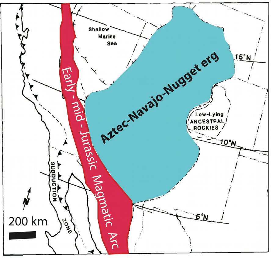
Before moving onto the diagenetic and structural details, it should be pointed out that the Aztec Sandstone is time equivalent to the Navajo and Nugget sandstones of the great Aztec-Navajo-Nugget erg (Figure 4) once covering a huge area of approximately 2000x1000 km squared in Nevada, Arizona, Utah, New Mexico, Wyoming and Colorado (Marzolf, 1986; Bilodeau and Keith, 1986). These formations were primarily made up of strongly cross-bedded quartz arenites. It is believed that the Aztec-Navajo-Nugget erg once formed one of the greatest hydrocarbon reservoirs. Today, these sandstones form many isolated aquifers providing ground water for some of the states mentioned above.
 | | Figure 4. Distribution of the Early-mid Jurassic Aztec-Navajo-Nugget erg within the Mesozoic back-arc basin of western North America. Redrawn from Bilodeau and Keith (1986). |
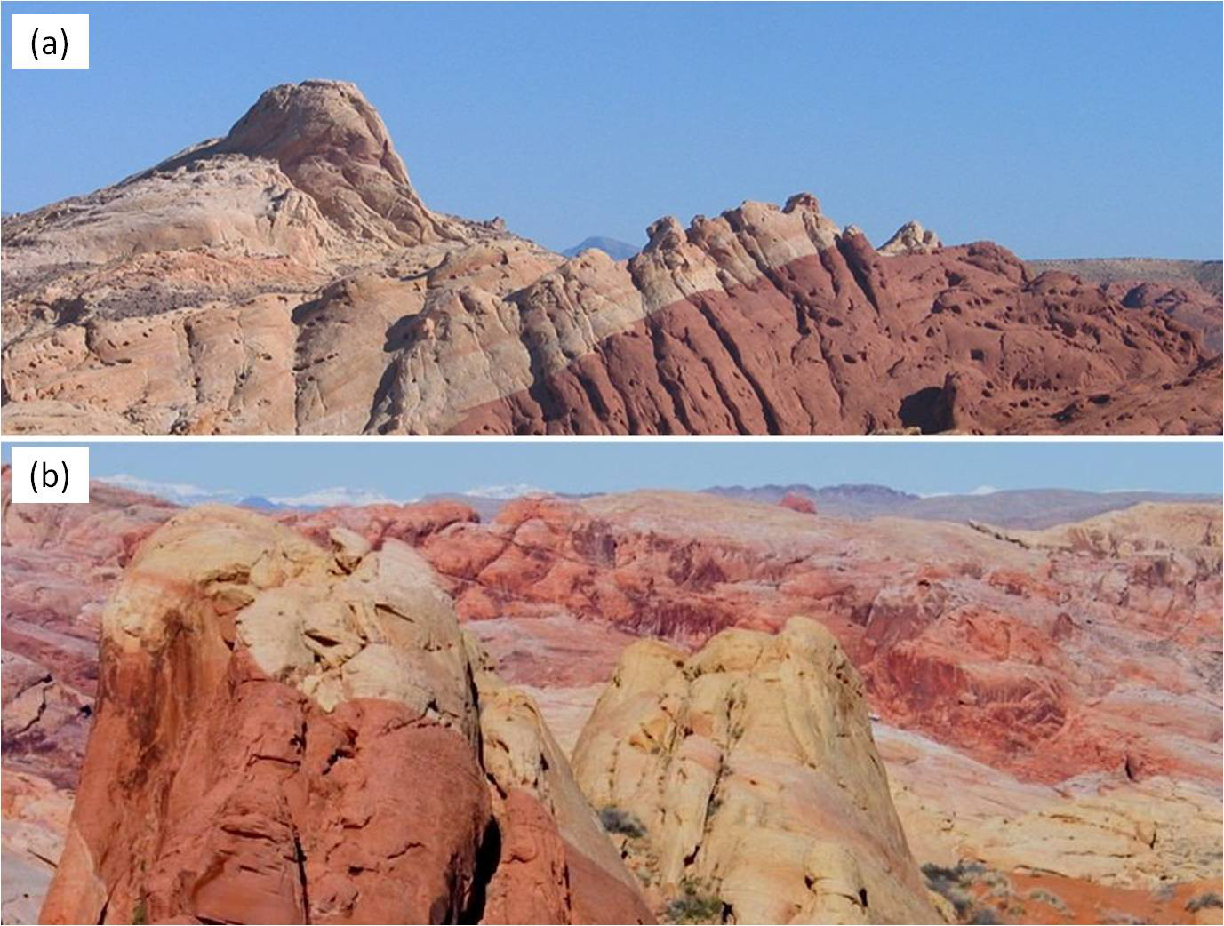
The Aztec Sandstone cropping out in the Valley of Fire State Park and its vicinity displays spectacular diagenetic alteration products responsible for colorful scenery in the park (Figure 5), which are closely related to the two deformation episodes (Figure 6 and Figure 7), the Sevier fold and thrust event and the Basin and Range normal and strike-slip faulting referred to above. Figure 6 is a series of schematic diagrams from Eichhubl et al. (2004) summarizing the relationships between the alteration types and the major depositional and tectonic events. The first stage is syndepositional reddening of the Aztec Sandstone due to hematite coating of quartz grains shortly after their deposition in the mid- to late-Jurassic. Reducing basinal fluids during the thrusting event removed some of the hematite coating so that parts of the formation regained a lighter complexion in the middle section of the formation. Finally the mixing of meteoric water and basinal fluids produced a spectrum of colors (Figure 5b) ranging from yellow, orange, and purple to brick red, which was attributed to the fluid-rock interaction during Tertiary.
 | | Figure 5. (a) A scenic view showing red and bluff color units of Aztec Sandstone at the Silica Dome area. View to the east. (b) Alteration units of various colors in the middle section of the Aztec Sandstone. View to the northwest. |
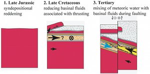 | | Figure 6. Summary diagrams illustrating schematically various alteration products within the Aztec Sandstone and their relationships to the depositional and tectonic events. From Eichhubl et al. (2004). |
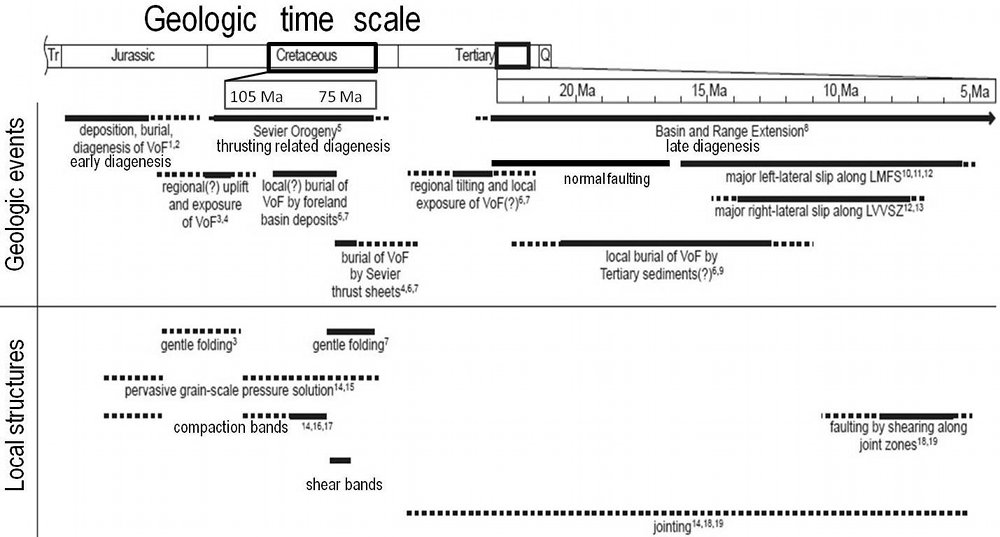
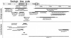 | | Figure 7. Summary of the geological history of the Valley of Fire and its vicinity. The events and the resulting structures are pointed out. Slightly revised from Flodin (2003). |
The Aztec Sandstone within the park displays a wide variety of structure types; deformation bands of various types and orientations, joints, sheared joints and faults. The diagram in Figure 7 from Flodin (2003) provides their chronology. Figure 8 includes some of these structures map-able only at a fine-scale to show their detailed geometry and distribution in an isolated dune well-preserved in a place named the Rainbow Vista rest stop.
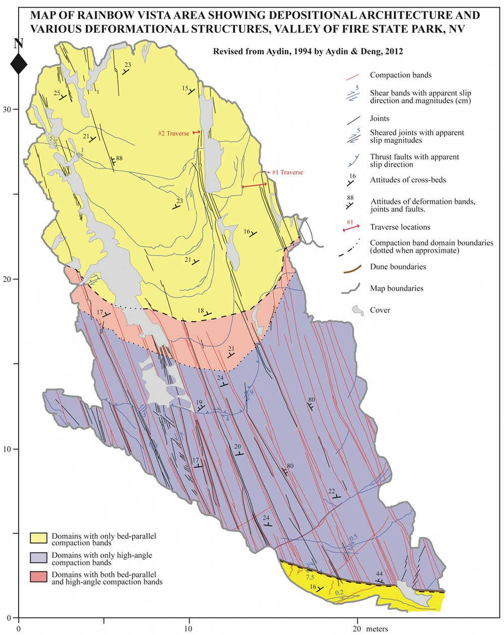
 | | Figure 8. Map showing depositional (dunes) and deformational (compaction bands, shear bands, joints, sheared joints, and faults) structures on a pavement at the Rainbow Vista in the park. Revised by Aydin and Deng (2012) from Aydin (1994). |
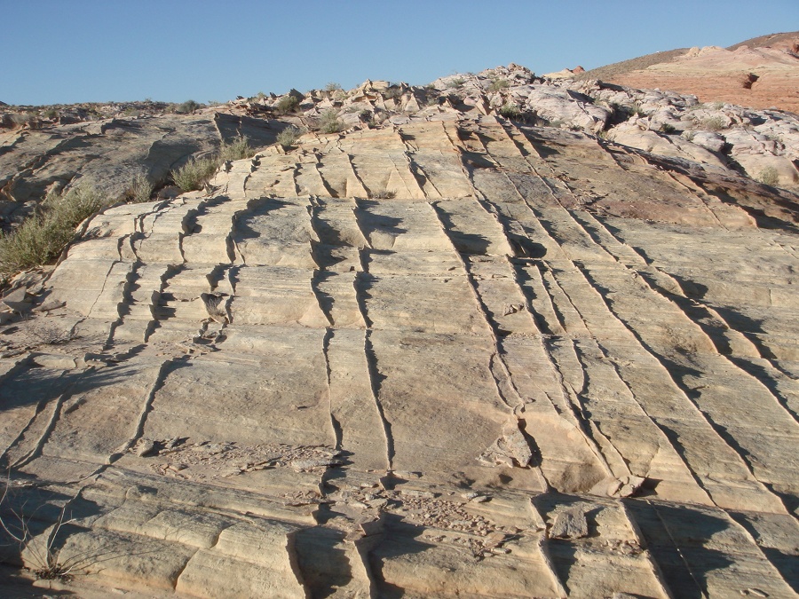
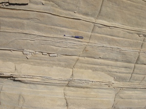
Hill (1989) reported three sets of compaction bands at high-angle to bedding and attributed them to the Sevier orogeny as will be reproduced in discussing compaction band class. Sternlof et al. (2005) mapped and characterized one of those sets (Figure 9) for the purpose of understanding their mechanical formation and fluid flow properties. These authors determined the closure and strain across them from a combination of thickness and porosity measurements. Aydin and Ahmadov (2009) reported the occurrence of bed-parallel compaction bands (Figure 10) and the possible role of shear-enhanced compaction localization in their formation. Eichhubl et al. (2010) reported that compaction bands occur in a wider range of orientations and modes and suggested a possible role of shearing in their formation. Recently, Deng and Aydin (2012; 2015) documented localization of compaction bands of various orientations in dunes (see Figure 11) and proposed that the nature of cross-beds and their orientation associated with the depositional architecture of dunes influence the presence and orientation of compaction bands and their compartmentalization into domains.
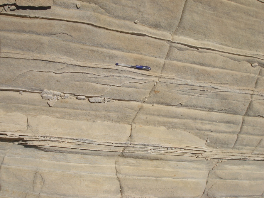
 | | Figure 9. A set of high-angle to bedding compaction bands in Aztec Sandstone, Valley of Fire State Park. |
 | | Figure 10. Bed-parallel compaction bands and their interaction in Aztec Sandstone cropping out about 0.5 km northwest of the Silica Dome, Valley of Fire State Park. View due North and the beds are dipping away from the viewer. Hammer for scale. |
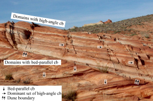 | | Figure 11. Localization of high-angle to the cross bedding (top dune) and low-angle, bed-parallel (bottom dune) compaction bands in dunes having strikingly different cross bed orientations. From Aydin and Deng (2012). |
Deformation bands of shear band types were recognized and were well studied in the park (see a more recent field trip guidebook by Aydin and Deng (2012). As they noted, shear bands also occur along dune boundaries and cross-bed interfaces in the park (Figures 8 and 12). Shear bands are present within and adjacent to the major thrust faults. For example, the Willow Tank thrust in Figure 3b near the paved park road to the White Domes has damage zones and fault rock full of shear bands of various orientations.
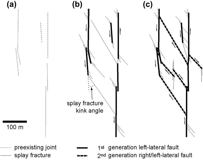
The younger generation (Tertiary) fractures in Aztec Sandstone in the park include widespread joints (Figures 13 and 14), which will be described in more detail later. The next pervasive structures are those faults which formed by shearing of joints and joint zones such as those described earlier. The relatively older faults are of normal types and generally have small offsets (typically less than about 10 m). These normal faults can be unambiguously identified at steep cliff faces along the Park Road such as those shown in Figure 15 and Figure 16. These faults are highly segmented and are surrounded by a dense population of splay fractures whose locations and orientation are consistent with the normal sense of shearing. The normal faults and the splays have similar strikes but the splays have steeper dip angles. Many of these splays were sheared sequentially resulting in a well-defined network of left- and right-lateral strike-slip faults (see the map in Figure 17). The strike-slip faults in the park with slip magnitudes ranging from a few millimeters (Figure 18a) to a few tens of meters (Figure 18b). Some of these strike-slip faults with a few hundred meters of slip(Figures 19 and 20) were studied in great detail by Myers and Aydin (2004) and Flodin and Aydin (2004). They established the initiation of the strike-slip faulting from shearing of a pervasive system of joints or joint zones as conceptualized by the sequential diagrams in Figure 21.
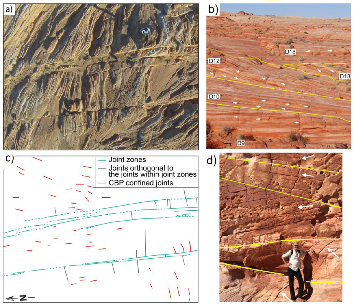
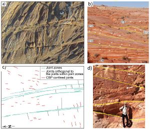 | | Figure 13. Common joint types in Valley of Fire State Park classified based on their geometry and orientation. (a) Image of an area in the park taken from an unmanned aerial vehicle. Sheng Deng on the upper right for scale. (b) Panoramic view of the area with the dunes and the cross-bed bounded joints immediately east of the aerial image. (c) Map of the area in (a) showing traces of three types of opening mode fractures: joint zones, joints at right angle to cross-bed interfaces (orthogonal joints), and cross-bed bound joints-CBJ. (d) Cross section view showing individual dunes and the joint sets therein with noticeably different trace geometry. Generally, joint zones have consistent orientation while CBJ vary in orientation as a function of the cross-beds. George Chittenden at lower right for scale. |
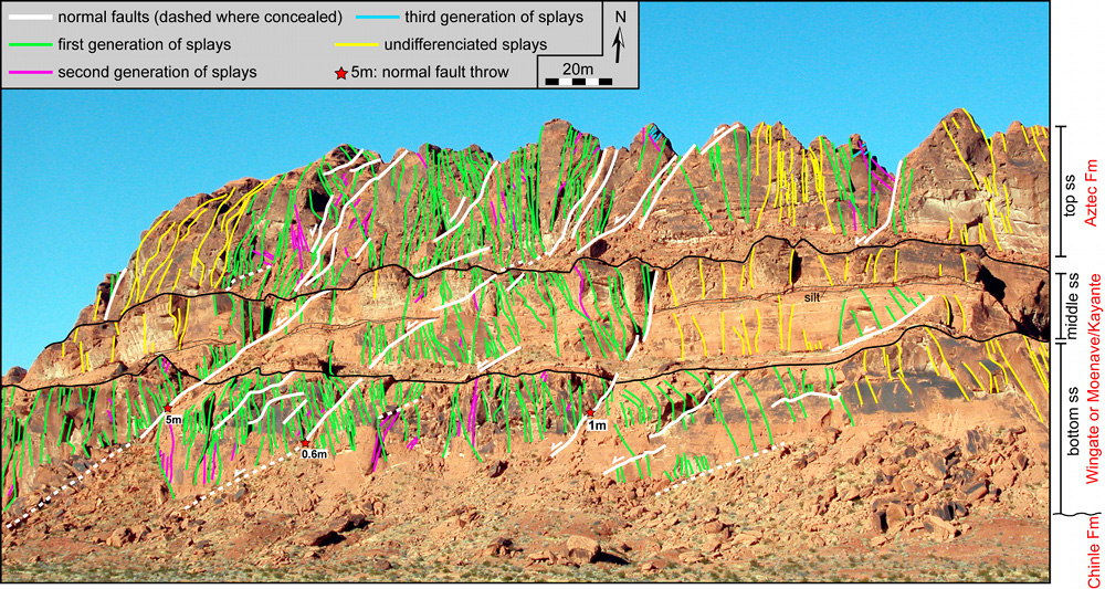
 | | Figure 15. Map showing structures exposed on the face of a steep cliff facing the Park Road. The three sandstone levels labelled as bottom, middle, and top are separated by interdune deposits of finer grain materials which form the flat levels in a staircase topography. The bottom two members lying over the Triassic Chinle Formation are thought to be the Jurassic Wingate-Moenave-Kayante and the top sand unit is definitely the Aztec Sandstone covering much of the park area. White lines mark normal faults with throw shown where measurable. Green lines are for the first generation splays and purple and blue are higher order splay generations. The nature of the fractures shown in yellow is not clear but they are likely to be in response to slip along interdune deposits. Slightly modified from de Joussineau and Aydin (2007a). |
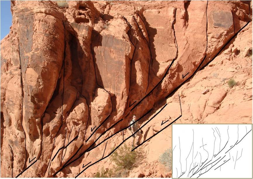
 | | Figure 16. A highly segmented normal fault and its splays as shown in the inset map. Notice that most splays emanate from the tip regions of the segments in the extensional quadrants of the fault segments. Fil Nenna at the center for scale. From Aydin and de Joussineau (2014). |
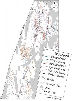
 | | Figure 17. Map showing left- and right-lateral strike-slip fault pattern in Aztec Sandstone in Valley of Fire State Park. This pattern is referred to as 'apparent conjugate' to differentiate it from the Andersonian type conjugate fault pattern. From Flodin and Aydin (2004). |
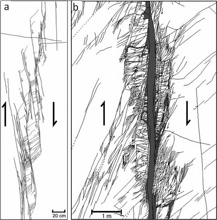
 | | Figure 18. Maps of two small left-lateral strike-slip faults formed by shearing of echelon joint zones: (a) an incipient fault with about 1 cm total slip and (b) a relatively well developed fault with 14 meters net slip, the photograph of which can be seen under 'Components of Faults.' Right-stepping echelon joint segments can still be recognized with high confidence in the case of the incipient fault in (a) but the initial joint system configuration has already been obliterated in the relatively well developed fault zone in (b). However, the second generation of echelon structures can still be delineated (see the section on 'Growth of Faults based on Sequential Shearing of Initial Discontinuities'). From Myers and Aydin (2004). |
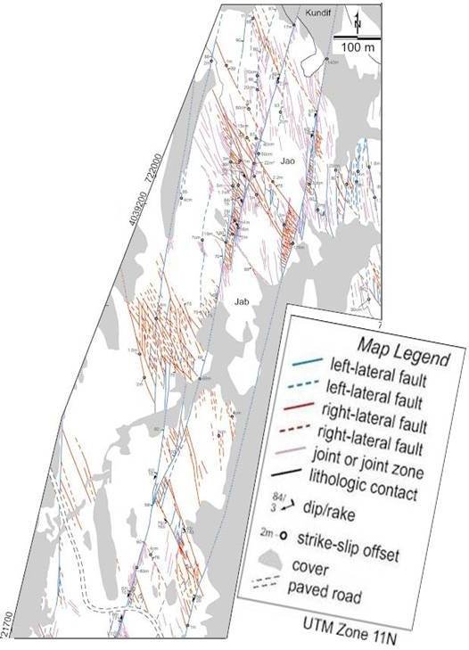
 | | Figure 19. Map showing detailed configurations of left- and right- lateral faults and their hierarchical geometry. The two major faults in the detailed map are the Lonewolf and Classic faults with left-lateral offsets locally of about 60 m and 170 m, respectively, in the view covered by the aerial photo in the next figure. From Flodin and Aydin (2004). |
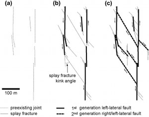 | | Figure 21. Conceptual model depicting development of two sets of strike-slip faults with an apparent conjugate pattern from a set of joints or joint zones (a) and sequential shearing of various generations of splay fractures (b and c) in Aztec Sandstone at Valley of Fire State Park, NV. Simplified from Flodin and Aydin (2004). |
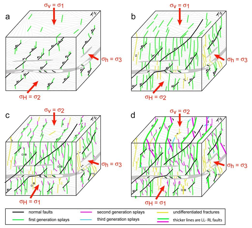
de Joussineau and Aydin (2007) and Aydin and de Joussineau (2014) proposed that the initial joints are related to an early extension and the associated normal faulting (Figure 22). However, some of the earlier joints appear to be joint systems not physically connected to any observable normal fault but consistent with this earlier extension direction. Regardless of a particular association, we refer to this sequence and the underlying process as the sequential shearing of initial joints or joint zones, splay fracturing, and shearing of the splay fractures.
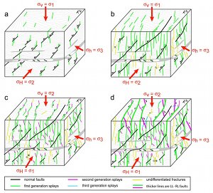 | | Figure 22. Conceptual models depicting the transition from an initial extension responsible for the normal faulting and jointing (a and b) to a predominantly strike-slip tectonics with both right- and left- lateral faults (c and d). The inferred remote stress orientations and their relative magnitudes associated with each stage are also marked. From de Joussineau and Aydin (2007). |
| |
Aydin, A., Borja, R., Eichhubl, P., 2006. Geological and mathematical framework for failure modes in granular rock. Journal of Structural Geology 28 (1): 83-98.
Aydin, A., Ahmadov, R., 2009. Bed-parallel compaction bands in Aeolian sandstone: Their identification, characterization and implications. Tectonophysics 479: 277-284, doi:10.1016/j.tecto.2009.08.033.
Aydin, A., Berryman, J. G., 2010. Analysis of the growth of strike-slip faults using effective medium theory. Journal of Structural Geology 32: 1629-1642, DOI: 10:1016/jsg.2009.11.007.
Aydin, A., Deng, S., 2012. The Stanford Rock Fracture Project 2012 Field Trip Guidebook. Stanford Digital Repository. Available at: http://purl.stanford.edu/pm733tn8209.
Aydin, A., de Joussineau, G., 2014. The relationship between normal and strike-slip faults in Valley of Fire State Park, Nevada, and its implications for stress rotation and partitioning of deformation in the east-central Basin and Range. Journal of Structural Geology 63: 12-26.
Bilodeau, W.L., Keith, S.B., . Lower Jurassic Navajo-Aztec-Equivalent Sandstones in Southern Arizona and Their Paleogeographic Significance. American Association of Petroleum Geologists Bulletin 70 (6): 690-701.
Bohannon, R.G., 1983. Geological map, tectonic map, and structure sections of the Muddy and northern Black Mountains, Clark County, Nevada, scale 1:62,500, 2 sheets. U.S, Geol. Surv. Misc. Invest. Map, I-1406.
Bohannon, R.G., 1983. Mesozoic and Senozoic tectonic development of the Muddy, north Muddy, and northern Black Mountains, Clark County, Nevada, in Tectonic and Stratigraphic Studies in the Eastern Great Basin, edited by D. M. Miller, V. R. Todd, and K. A. Howard. Mem. Geol. Soc. Am. 157: 125-148.
Carpenter, D.G., Carpenter, J.A., 1994. Fold-thrust structure, synorogenic rocks, and structural analysis of the North Muddy and Muddy Mountains, Clark County, Nevada, in Dobbs, S.W., and Taylor, W.J., eds., Structural and stratigraphic investigations and petroleum potential of Nevada, with special emphasis south of the Railroad Valley producing trend. Nevada Petroleum Society Conference II, p. 65-94.
de Joussineau, G., Mutlu, O., Aydin, A., Pollard, D.D., 2007. Characterization of strike-slip fault - splay relationships in sandstone. Journal of Structural Geology 29: 1831-1842, doi:10.1016/j.jsg.2007.08.006.
de Joussineau, G., Aydin, A., 2007. Normal faults as precursors to strike-slip faults networks in the Basin and Range province, Valley of Fire State Park, Nevada (USA). Stanford Digital Repository. Available at: http://purl.stanford.edu/jw080wt6699.
Deng, S., Aydin, A., 2012. Distribution of compaction bands in 3D in an aeolian sandstone: The role of cross-bed orientation. Tectonophysics 574–575: 204–218. http://dx.doi.org/10.1016/j.tecto.2012.08.037.
Deng, S., Cilona, A., Morrow, C., Mapeli, C., Liu, C., Lockner, D., Prasad, M., Aydin, A., 2015. Cross-bedding related anisotropy and its interplay with various boundary conditions in the formation and orientation of joints in an Aeolian sandstone. Journal of Structural Geology 77: 175-190.
Deng, S., Aydin, A., 2015. The strength anisotropy of localized compaction: A model for the role of the nature and orientation of cross-beds on the orientation and distribution of compaction bands in 3-D. Journal of Geophysical Research, Solid Earth 120: doi:10.1002/2014JB011689.
Eichhubl, P., Taylor, W.L., Pollard, D.D., Aydin, A., 2004. Paleo-fluid flow and deformation in the Aztec Sandstone at the Valley of Fire, Nevada-Evidence for the coupling of hydrogeologic, diagenetic and tectonic processes. Geological Society of America Bulletin 116: 1120-1136.
Eichhubl, P., Hooker, J.N., Laubach, S.E., 2010. Pure and shear-enhanced compaction bands in Aztec Sandstone. Journal of Structural Geology 32: 1873 – 1886.
Faulds, J.E., Hillemeyer, F.L., Smith, E.I., 1988. Geometry and kinematics of a Miocene “Accommodation Zone” in Wede, D. L., and Faber, M. L., eds., The central Black and southern Eldorado mountains, Arizona and Nevada, in This Extended Land Field trip guidebook. Geol. Soc. Am. Cordilleran Section Meeting, Las Vegas, Nevada: 293-310.
Flodin, E.A., 2003. Structural evolution, petrophysics, and large-scale permeability of faults in sandstone, Valley of Fire, Nevada. PhD Thesis, Stanford University.
Flodin, E.A., Prasad, M., Aydin, A., 2003. Petrophysical constraints on deformation styles in Aztec sandstone, Southern Nevada, USA. Pure and Applied Geophysics 160: 1589-1610.
Flodin, E.A., Aydin, A., 2004. Evolution of a strike-slip fault network, Valley of Fire State Park, southern Nevada. Geological Society of America Bulletin 116 (1-2): 42-59.
Hill, R.E., 1989. Analysis of deformation bands in the Aztec Sandstone, Valley of Fire State Park, Nevada. Master of Science thesis, University of Nevada, Las Vegas, 68p.
Liu, C., Pollard, D.D., Aydin, A., Deng, S., 2015. Mechanism of formation of wiggly compaction bands in porous sandstone: 1. Observations and conceptual model. Journal of Geophysical Research, Solid Earth 120: doi:10.1002/2015JB012372.
Myers, R., Aydin, A., 2004. The evolution of faults formed by shearing across joint zones in sandstone. Journal of Structural Geology 26 (5): 947-966.
Torabi, A., Aydin, A., Cilona, A., Jarsto, B.E., Deng, S., 2015. The dynamics and interaction of compaction bands in Valley of Fire State Park, Nevada (USA): Implications for their growth, evolution, and geostatistical property. Tectonophysics 657: 113-128. http://dx.doi.org/10.1016/j.tecto.2015.06.029.
|