|
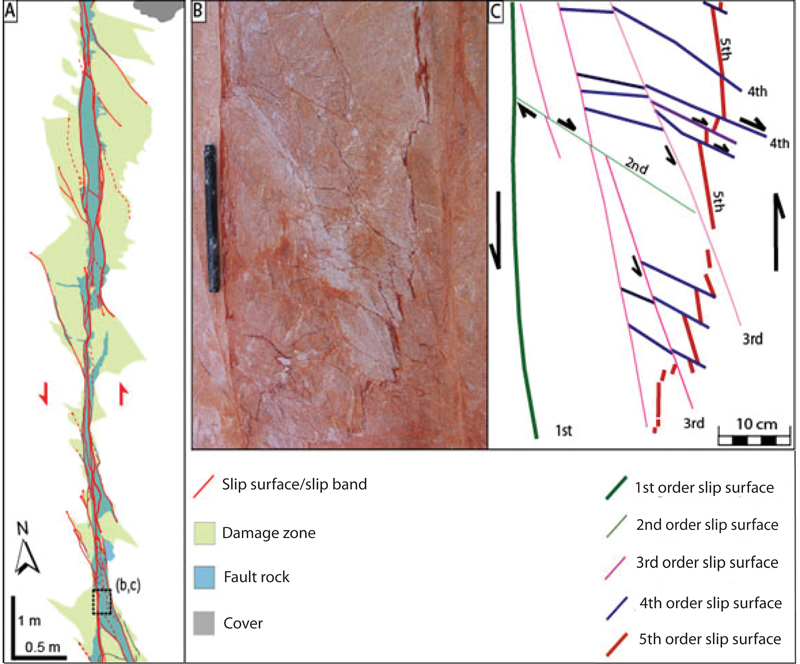
Faults, more than any other geological structures, have a zonal character due to friction and wear processes which are intrinsic properties of faulting and the large amount of shear and volumetric strains that they accommodate. Figures 1 a, b, and c show a map of a strike-slip fault zone with 14 m left-lateral slip in sandstone, which is also illustrated in 'Components of Faults.' By examining sequential formation of structural elements such as slip surfaces, fault rock, and damage zone within the fault zone, it is possible to establish how the fault zone grew progressively in length and width.
 | | Figure 1. A fault zone with 14 m left-lateral slip in aeolian sandstone exposed at Valley of Fire State Park, Nevada, showing various generations of slip surfaces. Thanks to thin redish infillings (slip bands), the slip surfaces can easily be traced on the outcrop; their intersection relationships reveal their relative temporal order. From Ahmadov et al. (2007). |
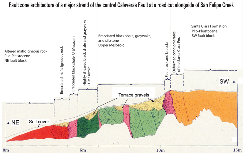
Well-developed faults with large slip occur in a broad scale. For example, the Calaveras Fault zone has several strands and accommodated about 20 km of right-lateral slip across a zone of 1 to 5 km wide (Figure 2). Figure 3 shows the exposure of one of the main strands of this fault alongside the San Felipe Creek (at the bottom of the map in Figure 2). Here the fault rock is about 9 m wide, and it includes several sub-zones composed of sheared units different than the host rocks in the SW and NE blocks at this locality. This fault rock distribution indicates that the fault zone was widened by incorporating different formations juxtaposed at various stages of faulting.
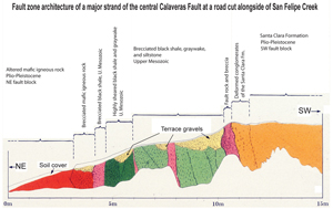 | | Figure 2. One strand of the Calaveras fault zone exposed alongside the San Felipe Creek. The fault zone is about 9 m wide and includes several high-shear zones. Mapped by B. M. Page, unpublished. |
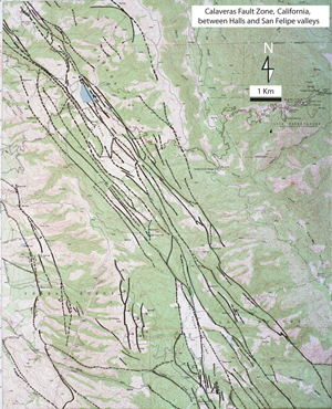 | | Figure 3. Fault strands within the central Calaveras Fault zone between Halls Valley in the NW and San Felipe Valley in the southeast. Mapped by Aydin and Page, unpublished. |
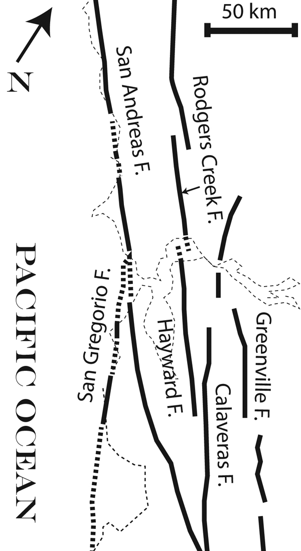
Perhaps some of the largest fault zones are those at the global plate boundaries. The San Andreas Fault zone separating the North American and Pacific plates at the latitude of the San Francisco Bay includes thousand of faults defining a zone about 100 km wide. Besides the San Andreas proper, other prominent faults making up the plate boundary include the San Gregorio, Hayward-Rodgers Creek, and Greenville faults, and the aforementioned Calaveras Fault (Figure 4). All these faults are presently active. The slip rate is greater than 2 cm per year on the main San Andreas Fault and about 1 cm per year on the Calaveras Fault.
 | | Figure 4. Major faults within the San Andreas system between the North American and Pacific plates in northern California. From west to east, San Gregorio, San Andreas proper, Hayward-Rodgers Creek, Calaveras, and Greenville faults. The San Andreas fault system is greater than 1300 km in length and 100 km in width. The right-lateral slip along the San Andreas fault zone is greater than 300 km since early Miocene. and more than one thousand kilometers since the inception of the fault zone. Simplified from Aydin and Page (1984). |
| |
Ahmadov, R., Aydin, A., Karimi-Fard, M., Durlofsky, L.J., 2007. Permeability upscaling of fault zones in the Aztec Sandstone, Valley of Fire State Park, Nevada, with a focus on slip surfaces and slip bands. Hydrogeology Journal: 10.1007/s10040-007-0180-2.
Aydin, A., Johnson, A.M., 1978. Development of faults as zones of deformation bands and as slip surfaces in sandstone. Pure and Applied Geophysics 116: 931–942.
Aydin, A., Page, B.M., 1984. Diverse Pliocene-Quaternary tectonics in a transform environment, San Francisco Bay Region, California. Geological Society of America Bulletin 95 (11): 1303-1317.
Flodin, E.A., Aydin, A., 2004. Evolution of a strike-slip fault network, Valley of Fire State Park, southern Nevada. Geological Society of America Bulletin 116 (1-2): 42-59.
Flodin, E.A., Gerdes, M., Aydin, A., Wiggins, W.D., 2005. Petrophysical properties and sealing capacity of fault rock from sheared-joint based faults, Aztec Sandstone, Nevada. in Sorkhabi, R., and Tsuji, Y., eds., Fault seals and petroleum traps: American Association of Petroleum Geologists Memoir, 85: 197-217.
Page, B.M., 1982. The Calaveras Fault Zone of California - An active plate boundary element. In, Hart, E. W., Hirschfeld, S. E., and Schulz, S. S. (editors), Proceedings of Conference on Earthquake Hazards in the Eastern San Francisco Bay Area. California Division of Mines and Geology Special Publication 62.
Wallace, R.E., 1990. The San Andreas Fault System, California. U.S. Geological Survey Professional Paper 1515.
|